I have to move Saturday's trail building to Sunday, May 4th.
Like last weekend. Meet at the Echo Valley lot, here is a map to the parking area.
Concentration will be on finishing the benching that was started last weekend and hopefully start some other benching.
There is still some treadway clearing that needs to be done in this area, too, as well as other areas further up the trail.
Monday, April 28, 2008
Rider Feedback on the Upper Gussy Trail
My first feedback on the Upper Gussy Trail who rode the trail without me leading the way. Equally impressive was that he was able to find the whole trail!
One note - thought I was done with the re-routing but there is still one more section that still needs some work.
The ride was nice although it took me a while to find it. I turned off the fire road--prematurely by the blue ribbon and blue blazes--which turned out to be a dead end, Further down, after riding on the fire road more, I saw the yellow ribbon and hopped on the trail.
It was very squishy at the north end (still top layer of organic) but I had a blast. A couple spots (as you had forewarned) were almost impossible to discern but after a dismount and careful examination of either the crushed leaves or the yellow ribbons, I figured out the trail direction.
I took the liberty of raking (with a sideways motion of my foot) a large part of the these areas that have yet to be raked. Also, at a couple of the larger logs, I located some flat rocks for ramps. The log jumps are still challenging but more conducive to "not stop the flow." There are a few awesome sections with lots of hairpin turns, especially after I crossed the stream, etc. I enjoyed the ride a lot and plan on returning (probably with my son) to stay on the bike more now that I know the line.
I "christened" our benched areas with tire marks and rode toward Sanford Road but turned around and headed back to the car where the trail disappeared into the leaves on the downhill.
I definitely will be back for more trail bldg whenever I can make it - I enjoyed that as well.
Congratulations on creating a potentially great place to ride!
Saturday, April 26, 2008
A perfect day for trail building!
 Today's turn out was much less than expected, which was disappointing, yet we were still able to get quite a bit of benching done in the phase I section of the trail. Total turn out was six people, three from the mountain biking community and three from NBLA. The mountain bikers consisted of Paula Burton, Rich Coffey and myself. The NBLA participants were Cindy Miller, Dee Davis, and Robin Thomson.
The bugs weren't that bad this time around. I think what helped, at least for me, was to wear a wide brimmed hat covered in copious amounts of bug spray. I found this spray from CVS which smells like latex paint that seems to work pretty well. Also adding to the favorable buggy situation was the weather. It was a chilly 50 degrees this morning with a slight wind. Later towards noon, when it had warmed up even more, the bugs came out in full force.
Rich and I started working on the benching that I started last week and we were able to get it done in about an hour. During that time, a photographer for the Danbury Newstimes showed up and took some pictures of us working. Meanwhile, Paula and Dee were working on the opposite side of where we were also benching and clearing some of the downed trees across the trail.


 Just as we finished that benching section a reporter from the Newstimes showed up. I escorted the reporter up and down the trail telling him about the history of the trail and it's intended use. He interviewed Robin, Cindy and Dee (shown below), and later Paula, too. It will be interesting to read how it comes out.
 Afterwards we gathered for a group shot after wrapping things up. Despite the low turnout, we go a lot of work down. Rich bought his bike and was going to try doing a loop that including riding the forest road and the Upper Gussy Trail but I haven't heard back from him on whether he was able to find the end from the fire road or not.

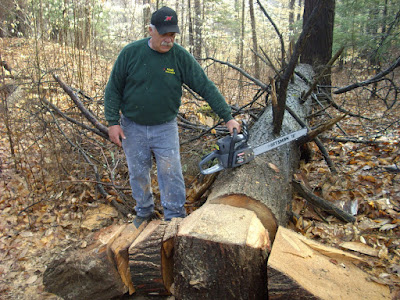
Here are the blow downs two months ago after Tom came through with his chainsaw.


The Upper Gussy is really starting to look like a trail!
Tuesday, April 22, 2008
April 26th, Trail Building, 9 am to 12 noon
On Saturday, April 26th, from 9 am to 12 noon I will be holding another Trail Building session. Please try to arrive around 8:30 to 8:45 to sign in.
If it's raining, then May 3rd is the next scheduled event.
If the lot is full, try to find a spot on Echo Valley Rd or Alberts Hill Rd.
Any questions, feel free to contact me.
Please ensure that you dress appropriately and wear boots or heavy duty shoes. Please bring work gloves, water and bug repellent.

If you arrive late and let's assume you park on Echo Valley Rd, the quickest way to where the work on the trail be happening is to walk up the driveway to the State Forest but at the yellow house, turn left and following the old road till it hits the State Forest boundary. That is the start of the ROW (Right of Way).
Directions to the parking lot at the end of Echo Valley Road:
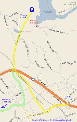
Directions to the parking lot at the end of Echo Valley Road:
From Exit 10 I-84
Turn Left if coming from the south/Turn right if coming from the north.Head west on US-6 [Church Hill Rd], for approximately 0.6 mi.
You will pass under a railroad bridge and when you see Starbucks on your left there will be a right turn onto the Boulevard.
Turn right onto the Boulevard and stay on this road for 1.3 mi.
When the road crosses under a highway bridge, it becomes Hanover Rd.
Take Hanover Rd for a half mile and Echo Valley Rd will be the first road on your right.
Turn onto Echo Valley Road and follow for 0.9 miles.
You will come up to a fork in the road and stay to the left. Continue for a few yards until the asphalt ends and a dirt road begins.
Do not turn left onto Sanford Road, there is a blue sign that says scenic road - that is the wrong direction.
Continue up the dirt road, passing a yellow house on your left and then a red barn and then you will come to the parking lot.

Sunday, April 20, 2008
Me, myself, and I ...
... oh, and don't forget the bugs! No body showed up at Echo Valley at 7:30 so I went at it alone. I think in about an hour I was able to do 10 yards of benching! As long as I was hunched over, the bugs weren't that bad but when you stood up you got the full buzzing attack. Their just gnats but are they annoying. I think next time I am wearing a floppy brimmed hat with plenty of bug juice.
 Still, not bad work for an hour's worth of time! Just think, if I could 10 yards in hour, if I had 10 people for 2 or 3 hours we could finish Phase I in probably a day! Probably going to dig that big hunk of quartz out next time.

 Still, not bad work for an hour's worth of time! Just think, if I could 10 yards in hour, if I had 10 people for 2 or 3 hours we could finish Phase I in probably a day! Probably going to dig that big hunk of quartz out next time.
Saturday, April 19, 2008
April 20th - Trail Building, Echo Valley Side

Forecast says rain right now for Sunday but look what happened last Saturday! Even if it's raining, there are still tons of things that can be done, like:
- Raking the trail path!
- Raking the trail path!
- Raking the trail path!
- Armoring the three stream beds
- Dig out some stumps in the ROW
- Raking the trail path!
Meet at the Echo Valley Lot at 7:30 am. Sunday.
Thursday, April 17, 2008
Now that's clearing a trail!


Below is a kind of then vs now map. The Green Track is from February when I was designing the trail myopically and the Red Track is what the trail is today, after lots and lots of input. This trail, for the most part was designed from North to South. After riding it in the other direction Sunday, it really opened my eyes to how the trail flows. There are still two areas that still need some tweaking but other than that, it's now a contiguous trail.

Sunday, April 13, 2008
Reversal of Fortune Details

Here are the details from my ride today (Reversal of Fortune Ride) on the Upper Gussy, only this time I rode the whole trail from Sanford Road to the Brody Road. Made some adjustments along the way, too. The detail section marked re-routed in the bottom part of the graphic above had been bugging me for the past month and it turns out as you come down the hill you would naturally go through the area that I now have the trail routed.
The section that we marked yesterday I cleared with my handy bike pruners. Everything looks good hear except for one little section that I think is too steep. I eyeballed it and I think the example below best represents how the last climb should run. This also ties in nicely should anyone on two wheels decide to drop the Rock-n-Roller or come through the stone wall and hit the roller on the other side, this will be a perfect funnel on the way down and a much more manageable ride on the way up.
 Thought I would share with you the some pix of the ROW (Right of Way) that I keep talking about. Below is the stonewall breach that Rich and Tren did an awesome job of dismantling and if you mash on the pedals after rounding through the other breach that was done back on March 29th you can catch a little air.
 Here is the other breach that opens into the Right of Way.
 This is the start of the ROW from the second breach. The orange markers are actually small stumps wrapped in orange engineer tape by Bob Butterworth after the Trails Workshop was over for future removal.
 Below is the view at the intersection with the Blue Blaze trail.
Past the Blue Blaze trail, where I used to have a little up-and-over on a log blocking the trail.
 In the Hemlocks
 Further into the hemlocks
 Leaving the ROW and heading toward the wet spot/rock garden.
 The Rock Garden/Wet Spot Crossing
Saturday, April 12, 2008
April 12 Trail Building

Tom and I met at Pond Brook this morning. We planned on rain or shine and fortunately the rain rolled in at around 5 AM and was done before 6. Tom brought his chain saw and I decided to bring the pry-bar. Man is that thing heavy! It was like I was back in the Army humping an M-60 and playing ammo bearer at the same time. It was worth bringing it though because it got some usage.
We started on the connector trail, then hit my secret sauce trail as a short-cut to the Brody Road. We took the Brody to the Yellow trail and then to the Blue trail, back on the Yellow till we hit the Upper Gussy. Getting to this side of the trail carrying tools, water, additional gear and that freaking pry bar was a bear!
We worked on the up-and-over at the downed fir tree. The chain saw came in pretty handy but I think the northward side ramp (to Tom's right) needs to flipped over so that it creates more of a ramp if you wanted to hit it from the other direction.
Then we went over to the two rock ridges and cleared out the middle section. Tom showed me some alternative routes for horses to climb up the first ridge which will work for bikes but coming down the other side has always been a little sketchy, especially with these three big rocks in the way. So we moved on out of the way to open it for future benching.We started on the connector trail, then hit my secret sauce trail as a short-cut to the Brody Road. We took the Brody to the Yellow trail and then to the Blue trail, back on the Yellow till we hit the Upper Gussy. Getting to this side of the trail carrying tools, water, additional gear and that freaking pry bar was a bear!
We worked on the up-and-over at the downed fir tree. The chain saw came in pretty handy but I think the northward side ramp (to Tom's right) needs to flipped over so that it creates more of a ramp if you wanted to hit it from the other direction.


On the other side of the second rock ridge we opened a section that would be the best way for the horses to go. Made a log corduroy but come to think about it it's really not that challenging. Then we headed down to last tree that was blocking the trail and finished cutting that. Then we levered it into position so that an existing rock that that is ramped could be used to make it into a log ride.
 Just need to build a ramp on the other side and this stunt will be complete. The trail will be benched above the log ride and I might build a little connector off the trail.
 We spent the last 30 minutes walking the section that I rerouted the other day. Marked it with tape and Tom had some great suggestions that I incorporated into the trail.
The Old Bucket

For now, the bucket covers a stump of where the trail will go, between the trees and the big rock in the back ground. The trail will split off to the left for horses and bikers coming the other way (north) after the big clump of trees, which is after the big rock you see. Further off in the distance the trail (for bikers heading south and looking for something to play on) is a large rock outcropping that you will be able to roll or ride over it's entirety and drop the other side.

Friday, April 11, 2008
Short notice work day 4/12

Rain or shine, 7:15 am to 10:30 am.
Tom and I are meeting at Pond Brook Boat Ramp.
We will be working in Phase III & Phase IV areas.
If you come late, park at the boat ramp, walk up the connector trail to the Brody Road. Take the Brody until you see green tape marking the trail head. We'll be ensuring that the trail is clearly marked to the stream crossing (which includes the re-route).
Wednesday, April 9, 2008
Re-Routing The Trail

I think if you click on the map above it be clearer to view.
Once you get around the first outcropping, which I will have to examine closer for drop and roller potential, the route I chose comes to a really big exposed rock that you can roll, ride down the side, or drop further off. For the horses, there is a go around through an existing breach in the stonewall, looks like it was made by a skidder. On the other side are more exposed rock that definitely has roller and drop potential. The trail then hooks around back and moves down the slope at a nice angle and keeps coming around till it lines up perfectly with route to the stream crossing. I will get pictures next time through when I go in to mark that section of the trail.
Below is the start of a stunt at the big fir. When Tom cut this up, he made it too wide, however, I rolled one of the pieces back into the opening which narrowed it down some. Might want to consider putting a smaller log in here to prevent an ATV from having easy access. If they are going to be on this trail illegally I am going to make it as hard as possible for them to have a good time. What I am going to do is dig out a hole for this chuck on log to sit in so that it's flush with the ramps on either side, which will make it a fun little challenge.


Monday, April 7, 2008
New Stream Crossing


Below is looking to the North East.

This is the view looking South West. Due West the hillside is much steeper so the trail, once crossing the stream will run parallel for twenty yards and then make a sweeping turn back to the North, up on higher ground and continue that direction.

Sunday, April 6, 2008
Trail Construction Phases

Construction of the Upper Gussy Trail will be in five phases. The reason for these phases is so that we can keep control of what is going on in a particular area and ensure that people know where to go in the event of they come late to a trail building session. I would appreciate that if anyone wants to go out and do work by themselves to contact me and ensure they are familiar with the area that they are going to work in and know what has to be done.
For the most part, the route of the trail is clear in Phases I, II, and part of III. Only stuff left for clearing in these three phases have been marked with yellow spray paint.
The top part of Phase III and the section of Phase IV past the downed fir tree still need to be marked and hopefully that will be done by next weekend. Phase V is completely cleared because this is an existing trail. The only work needed here, besides some benching further up the trail, will be a big benching project to get up the other side of the stream bank.
Phase Decriptions
Phase I: Starts at the Trail Head on the Jeep/Logging Trail that comes off of Sanford Rd and ends at the ROW. The ROW is the section of an old farming road that is lined with stone walls. This section of the trail crosses the blue blazed trail twice.
Phase II: Begins at wet area crossing, winds up behind a ridge, goes by a big vernal pool, makes the two stream crossings, picks up the old logging road for 100 yards and then makes it's way to the third stream crossing.
Phase III: Starts at the third stream crossing and ends where the the old logging road seems to disappear in the forest. There is an old trail at this point that connects to the blue trail.
Phase IV: Begins at the old trail and heads back towards another big vernal pool, follows between some small ridges, goes over two small ridges and then picks up the existing trail at the downed fir tree.
Phase V: Is the Pond Brook connector trail.
Subscribe to:
Posts (Atom)
-
 My daughter and I went for a hike New Year's Day and upon arriving at the Boat Ramp I was dismayed to see there was a mountain biker ou...
 -
 This trail has been in the making for four years and it's finally coming to fruition! Just waiting on the final approval from the CT DE...
 -
 After adding a flow section on the north end of the Upper Gussy Trail ( Cyclesnack: Adding Some Flow to the Gussy ) I headed down the trail ...