Online Map

Showing posts with label Phase I. Show all posts

Tuesday, April 22, 2008

April 26th, Trail Building, 9 am to 12 noon

On Saturday, April 26th, from 9 am to 12 noon I will be holding another Trail Building session. Please try to arrive around 8:30 to 8:45 to sign in.

If it's raining, then May 3rd is the next scheduled event.

If the lot is full, try to find a spot on Echo Valley Rd or Alberts Hill Rd.

Any questions, feel free to contact me.

Please ensure that you dress appropriately and wear boots or heavy duty shoes. Please bring work gloves, water and bug repellent.


If you arrive late and let's assume you park on Echo Valley Rd, the quickest way to where the work on the trail be happening is to walk up the driveway to the State Forest but at the yellow house, turn left and following the old road till it hits the State Forest boundary. That is the start of the ROW (Right of Way).

Directions to the parking lot at the end of Echo Valley Road:
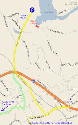
From Exit 10 I-84
Turn Left if coming from the south/Turn right if coming from the north.Head west on US-6 [Church Hill Rd], for approximately 0.6 mi.
You will pass under a railroad bridge and when you see Starbucks on your left there will be a right turn onto the Boulevard.
Turn right onto the Boulevard and stay on this road for 1.3 mi.
When the road crosses under a highway bridge, it becomes Hanover Rd.
Take Hanover Rd for a half mile and Echo Valley Rd will be the first road on your right.
Turn onto Echo Valley Road and follow for 0.9 miles.
You will come up to a fork in the road and stay to the left. Continue for a few yards until the asphalt ends and a dirt road begins.
Do not turn left onto Sanford Road, there is a blue sign that says scenic road - that is the wrong direction.
Continue up the dirt road, passing a yellow house on your left and then a red barn and then you will come to the parking lot.


Saturday, April 19, 2008

April 20th - Trail Building, Echo Valley Side


Forecast says rain right now for Sunday but look what happened last Saturday! Even if it's raining, there are still tons of things that can be done, like:
  1. Raking the trail path!
  2. Raking the trail path!
  3. Raking the trail path!
  4. Armoring the three stream beds
  5. Dig out some stumps in the ROW
  6. Raking the trail path!
If it's raining, come dressed appropriately. If it's not raining, then we'll do some benching, too!

Meet at the Echo Valley Lot at 7:30 am. Sunday.

Thursday, April 17, 2008

Now that's clearing a trail!

Came across Tom this afternoon clearing the ROW while I was riding. His rake broke so he had to resort to an alternate means. Now all we have to do is define the treadway to encourage people not to use the middle of the ROW, which is really the drainage ditch.


Below is a kind of then vs now map. The Green Track is from February when I was designing the trail myopically and the Red Track is what the trail is today, after lots and lots of input. This trail, for the most part was designed from North to South. After riding it in the other direction Sunday, it really opened my eyes to how the trail flows. There are still two areas that still need some tweaking but other than that, it's now a contiguous trail.

Saturday, April 5, 2008

April 5th - Actual


The weather wasn't really too sketchy afterall. It rained all day yesterday and was quite nice this morning. Tom and I met at 7:45 am and walked from the Echo Valley lot to the Old Tree that he cut part way through the other night. Along the way we did some trail clearing and some further re-routing in Area #2 on the above map. I think we also might have found a better crossing of the brook, further down where I had intended on crossing. It's alot flatter and ties in nicely with some other terrain features.

We got as far as the Old Tree and then had to turn back because it was quarter to nine. I ran ahead back to the parking lot to see if anyone showed up for the scheduled trail buidling day and there wasn't anybody. I did, however, run into a hiker by the name of Jeff Pritchart and asked if he was interested in helping out and he said sure. Jeff said that he is in the forest quite often before work hiking and had noticed the new trail.

Jeff and I went in via the Blue Blazed, then picked up the Gussy Trail and followed it towards Sanford Road but took a short cut down to the rock wall that I wanted to finish breaching at Area #3 on the map above. Tom was already there rolling a few rocks around.


Once we got it open, the difficult part began by trying to install a stable tread way. We used a few of the flat rocks from the wall and then filled in the gaps with soil. After a good rain, the water should wash off the soil on the rocks and we should have a nice tread way through the wall. Jeff is show below smoothing out the last area of dirt, while his dog, Peyton, checks out the rock wall. We found a live shotgun shell in the wall but very corroded.


Below is the finished product. To ensure users stick to the trail, we piled the excess rock and a few trees on one side to force them to around the bend.

Here is the breach from the other side.


Once you round the trees, the trail heads down a gentle slope that I originally had going through the two trees in the middle of picture below but after looking at thought it might be better to go around them so as to take the sharp left turn out and gives a more wavy feeling to the trail.


Jeff is pictured with his dog Peyton below. We finished the rock wall and started removing the duff off the future treadway. Jeff had to leave at this point.


We continued clearing duff in the opposite direction and pruned the hemlock that the trail goes under. One of the things you have to keep reminding yourself when building a multi-use trail such as this is that when you trim low hanging branches, you have to consider the rider atop a horse. In most cases, the horseback rider is already four to six fee up above the ground so you have prune up pretty high. Mountain bikers are much lower to the ground. Below is what the trail now looks like heading to the stonewall breach.

And here is what it now looks like from the opposite direction. I have to thank Paula again for coming back last Sunday and re-flagging some additional sections for benching. On the trail walk last month, Cindy thought it would be better to swing the trail out further when coming from the roller/intersection with the Blue Blaze trail. After looking at it again, I liked the changed and it's now a part of the trail.

This new curve in the trail can be seen on the map above as Area #4. Tom brought up an interesting point, that we should designate sections of the trails as phases so that when we have a trail building day and we can tell people where to look for us if someone were to show up a little late.

Case in point, Robin Thomson was an hour late, walked up the ROW and down the trail but turned around after some point. We found her walking back up the ROW while we were clearing out the section of trail we were working on. In the future, trail building days will be within specific locations or phases. So, you will see a new map with the trail broken into sections coming soon.


Above are Tom pruning up high and Robin clearing the cuttings. We wrapped up at 11:45.