Made a first pass at re-routing the trail so that users are not enticed into short cutting the trail around the new stream crossing and did I found some juicy nuggets back there. It's funny when designing a trail and you are set on going through a particular area, whether it's for convience, ease, or topography restrictions, when you move a little further away it can be surprising what you might find. Case in point, after I found the best path on the first slope, where I have indicted will require benching, I found an old pail sitting out in the open. Nothing else around except for an old rusted pale.
Once you get around the first outcropping, which I will have to examine closer for drop and roller potential, the route I chose comes to a really big exposed rock that you can roll, ride down the side, or drop further off. For the horses, there is a go around through an existing breach in the stonewall, looks like it was made by a skidder. On the other side are more exposed rock that definitely has roller and drop potential. The trail then hooks around back and moves down the slope at a nice angle and keeps coming around till it lines up perfectly with route to the stream crossing. I will get pictures next time through when I go in to mark that section of the trail.
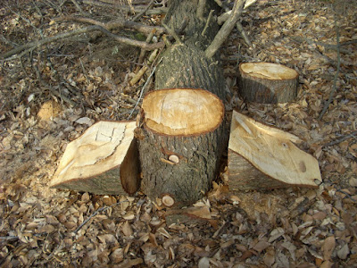
Below is the start of a stunt at the big fir. When Tom cut this up, he made it too wide, however, I rolled one of the pieces back into the opening which narrowed it down some. Might want to consider putting a smaller log in here to prevent an ATV from having easy access. If they are going to be on this trail illegally I am going to make it as hard as possible for them to have a good time. What I am going to do is dig out a hole for this chuck on log to sit in so that it's flush with the ramps on either side, which will make it a fun little challenge.
Below is a climb that Paula flagged that will need benching. This picture is facing north.
This picture is facing south. After the last flag the trail does an almost hair pin turn which lines it up for the run over to the blow downs and entrance to the ROW.
Subscribe to:
Post Comments (Atom)
-
My daughter and I went for a hike New Year's Day and upon arriving at the Boat Ramp I was dismayed to see there was a mountain biker ou...
-
This trail has been in the making for four years and it's finally coming to fruition! Just waiting on the final approval from the CT DE...
-
After adding a flow section on the north end of the Upper Gussy Trail ( Cyclesnack: Adding Some Flow to the Gussy ) I headed down the trail ...


No comments:
Post a Comment